
Research & Development
Enhance your information services with our industry-leading cloudmask technology and advanced Analysis Ready SAR Data, ensuring you meet and exceed customer expectations.
CHIME + LSTM + ROSE-L: Assessment of Yield Quantity and Quality (CHILL-Y)
Synergistic use of CHIME, LSTM, and ROSE-L data for the assessment of yield quantity and quality
Duration 2025 –2026
Funder European Space Agency
Partners VISTA, VITO, EurA AG
- Develop a novel service to assess wheat and sugar beet yield and quality using simulated future data from CHIME, LSTM, and ROSE-L satellite missions.
- Agricultural parameters from representative datasets integrated into a crop growth and AI model to estimate and map yield quantity and quality.
- Novel datasets and methods tested across European sites.


Estimation of forest volume and forest height in hemiboreal forests from multi-static synthetic aperture radar
Developing a transparent methodology for estimating forest height and volume based on satellite data
Duration 2024-2028
Funder European Regional Development Fund; amount of the grant 124 703 €.
- Demonstrate the influence and importance of various polarimetric variables on forest height and volume estimation.
- Develop a reliable and transparent methodology for forest height and volume estimation in hemiboreal forests.
Forest Volume and Carbon Stock Modelling Based on Satellite Observations to Accelerate the Green Transition and Enhance Carbon Market Transparency (SAR4EST)
Satellite-based forest growing stock volume (GSV; m3/ha) and sequestered carbon stock (CO₂; t/ha) estimation in Northern Europe (north of the Alps)
Duration 2024-2026
Funder Estonian state budget; amount of the grant 718 236 €
- Models for estimating GSV (i.e. timber volume) at the stand level (Northern Europe)
- Model for estimating CO₂ stock at the stand level (Northern Europe)

EO-based open landscape trafficability monitoring for national security and agricultural applications
Timely EO-based open landscape trafficability monitoring solution
Duration 2024–2026
Funder European Space Agency
- Demonstrate the feasibility and potential benefits of using satellite data for estimating landscape trafficability.
- Develop AI models that accurately estimate landscape trafficability with a high spatial resolution.
- Develop a user-friendly daily trafficability service accessible via the Open Geospatial Consortium (OGC) standard interface for end-users, ensuring real-time access to trafficability information.
KappaOne S1 ARD layers – weather independent vegetation index
Cloud-independent agricultural monitoring solution
Duration 2024–2025
Funder European Space Agency
- Develop consistent and accurate sNDVI data that is unaffected by cloud cover.
- Provide the sNDVI solution to agricultural experts to navigate changing conditions with greater confidence and agility, regardless of weather patterns.
Assessment of Timber Stock and Modeling of Carbon Stock Based on Satellite Remote Sensing to Accelerate the Green Transition and Increase Transparency of the Carbon Market
Satellite-based forest growing stock volume and CO₂ stock estimation in Estonia
Duration 2024–2025
Funder European Regional Development Fund; amount of the grant 98 102 €
AI-based tillage detection for improved agricultural and climate policies
AI-based tillage detection for improved agricultural and climate policies
Duration 2023–2024
Funder European Space Agency
- Feasibility study of conservation (i.e. non-inversion) tillage detection with satellite imagery.
- Tillage detection AI models for different tillage types based on Sentinel-1, Sentinel-2, Landsat 8 & 9 imagery time series.
Satellite monitoring services for crop insurance
Enabling novel and more efficient solutions for customer pooling and loss adjustment processes in crop insurance.
Duration 2022 – 2023
Funder European Regional Development Fund and Enterprise Estonia; amount of the grant 434,760 €.
AI-based Cloud Mask Processor for Sentinel-2 : Phase 2
Extending the "KappaMask" processor developed under Phase 1 of the project “AI-based Cloud Mask Processor for Sentinel-2” to global coverage.
Duration 2021–2022
Funder European Space Agency
- KappaMask extended to global conditions, which is compatible with ESA Sentinel-2 L2 processing chain. View KappaMask (GitHub)
- KappaSet, the Sentinel-2 cloud and cloud shadow dataset, distributed geographically throughout all seasons over the globe. View KappaSet
AI-based Cloud Mask Processor for Sentinel-2
Develop new and better cloud mask than existing ones
Duration 2020–2021
Funder European Space Agency
- Reliable cloud mask processor for Northern Europe region, which is compatible with ESA Sentinel-2 L2 processing chain.
- Create high quality reference dataset for future developments.
- Use innovative deep learning techniques in cloud masking.

Grazing detection from Copernicus data for agricultural subsidy checks
A complete satellite-based grassland monitoring service
Duration 2020–2021
Funder European Space Agency
Partners Gisat s.r.o
- Develop grazing detection methodology based on Copernicus data (Sentinel-1 and Sentinel-2 imagery time series).
- Provide the NPA operators means to carry out checks on grasslands using EO data and substituting on the spot checks of grassland grazing activity with new EO data based grazing detection methodology.
- Close the grasslands subsidy checks case for CAP satellite monitoring.
Harvesting Time Recommendation for maximum crop Yield (HaTRY)
Predicting the best time to harvest crop using remotely sensed data
Duration 2020–2021
Funder European Space Agency
Partners Local farmers in Estonia
- Prototype service for Precision Farming application to predict and recommend the most favorable harvesting time for maximum crop yield.
- Focus on Northern Europe region and three most common crops: winter wheat, spring barley and winter rapeseed.
- Learn and collect farmers requirements for a fully operational service.
National Programme for Addressing Socio-Economic Challenges through R&D (RITA). Using remote sensing data in favour of the public sector services
Monitoring the use of agricultural land
Duration 2019–2020
Funder This study was financially supported by the European Regional Development Fund within National Programme for Addressing Socio-Economic Challenges through R&D (RITA).
Partners Consortium team: University of Tartu, Tallinn University of Technology, Estonian University of Life Sciences, KappaZeta Ltd
- Mature, reliable and tested crop classification methodology development specifically suited for Estonian agricultural, ecological and climatic conditions.
- Multi-year country-wide testing and error analysis about vegetative seasons 2018–2020.
- Crop classification model prototype with test datasets.
ESA Business Incubation
Improving our software quality during the incubation phase
Duration 2018–2019
Funder European Space Agency
Partners University of Tartu (Institute of Computer Science), Sookolli Kaardid OÜ, Elmer SKB OÜ, Codeborne OÜ
- Satellite imagery model development
- Software architecture definition and review
- Software implementation
- Market analysis and business plan development
- Improved web map for visualizing our analysis results

Detection of mowing events on grasslands from Sentinel-data
The first nation-wide system for automated monitoring of agricultural practices in EU
Duration 2016-2018
Customer Estonian Agricultural Registers and Information Board (ARIB) Partners: CGI Estonia, Tartu Observatory
- Nation-wide fully automated mowing detection system operational in Estonia from 2018
- Sentinel-1 and Sentinel-2 time-series for operational near real-time monitoring
- 85% of detection accuracy of the mowing events on grasslands
- Automated “early warning” reminders to applicants

Grassland mowing detection for agricultural subsidy checks with Sentinel-1 and Sentinel-2
Looking over the borders to Denmark, Sweden and Poland
Duration 2017-2019
Customer European Space Agency, Industry Incentive Scheme (ESA IIS)
Partners The Danish Agrifish Agency, the Swedish Board of Agriculture, The Agency for Restructuring and Modernisation of Agriculture in Poland, Reach-U Ltd
- Validate the service by performing user trials in Sweden and Denmark
- Enhance the existing cutting and grazing detection methodology
- Study Earth Observation Community Platform (EO CP) service providers
- Perform Viability Analysis

Data Analytics for Optimizing Agricultural Monitoring
Going beyond the mowing detection powered by high-level data analytics expertise
Duration 2017-2018
Funder Enterprise Estonia, project No. EU48684
Partners Software Technology and Applications Competence Centre (STACC)
- Develop a scientifically validated methodology for ploughing and grazing events detection from Sentinel-1 and Sentinel-2 time series
- Bring to customers a new cultivation and grazing detection product prototype
- Involve high-level data analytics expertise powered by STACC.
Home page and demo application
KZ branding, home page and demo application. In partnership with Reach-U, Kiften, Jon & Pun
Duration 2017
Funder Enterprise Estonia, project No. EU51738; amount of the grant 14,960 €
- KZ branding
- Home page
- Mowing detection demo application
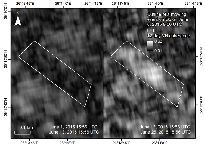
Relating Sentinel-1 Interferometric Coherence to Mowing Events on Grasslands
- the effect of grassland mowing on interferometric coherence calculated for a Sentinel-1 pair separated by 12 days
- The coherence increases after a mowing event, but the effect wears off in a couple of weeks
- Precipitation counteracts this effect
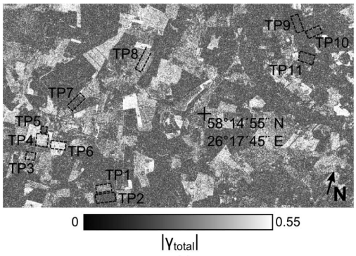
Monitoring of Agricultural Grasslands With Time Series of X-Band Repeat-Pass Interferometric SAR
- Using COSMO-SkyMed acquisition pairs separated by one day, the relationship between grassland mowing and interferometric coherence was noticed
- Precipitation and further agricultural activity on parcels after mowing may negate the coherence increase
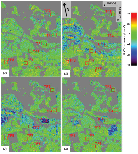
Observations of Cutting Practices in Agricultural Grasslands Using Polarimetric SAR
- SAR polarimetry also provides means to detect mowing events from TerraSAR-X data products
- Polarimetric parameters such as HH/VV polarimetric coherence and alpha angle of the H/alpha decomposition are sensitive to mowing
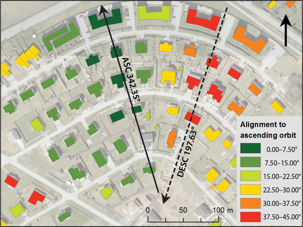
Sensitivity of Sentinel-1 backscatter tocharacteristics of buildings
- Sentinel-1 backscatter statistics respect to the physical parameters of the buildings
- Backscatter dependence on building height, material, orientation angle and shape
- Alignment effects due to Sentinel-1 orbit and look angle