
This is Part 2 of our series on looking into our trafficability mapping solution. See Part 1. Exploring the Significance of Open Landscape for Trafficability Mapping here.
Trafficability mapping assesses whether terrain can support the movement of vehicles, equipment, or personnel. Two of the most critical inputs are soil moisture and essential soil properties. While soil moisture changes frequently, essential soil properties define how a soil responds to moisture and mechanical loading. Together, they determine load-bearing capacity, rutting risk, sinkage depth, and overall mobility.
Trafficability mapping integrates soil, terrain, weather, and land cover data to predict where and when ground vehicles can operate safely and efficiently. Among these variables, soil moisture is often the dominant controlling factor because it directly affects soil strength, bearing capacity, and rutting susceptibility.
Soil moisture is a dynamic variable that changes daily with rainfall, evapotranspiration, irrigation, drainage, and snow melting cycles. It influences:
- Shear strength
- Temporal variability
- Load-bearing capacity
As soil moisture increases:
- Pore spaces fill with water
- Effective stress decreases
- Soil strength declines
- Rutting and sinkage increase
At saturation, many fine-grained soils (e.g., clay, silt) lose substantial structural integrity, severely limiting vehicle mobility.
The table below shows the relationship between soil moisture and trafficability:
| Soil condition | Trafficability impact |
| Dry | High bearing capacity, low rutting risk |
| Moderately moist | Optimal for agriculture |
| Wet | Reduced strength, increased rutting |
| Saturated | High immobilization risk |
Even slight changes in volumetric water content can drastically alter vehicle performance, particularly in clay-rich or organic soils.
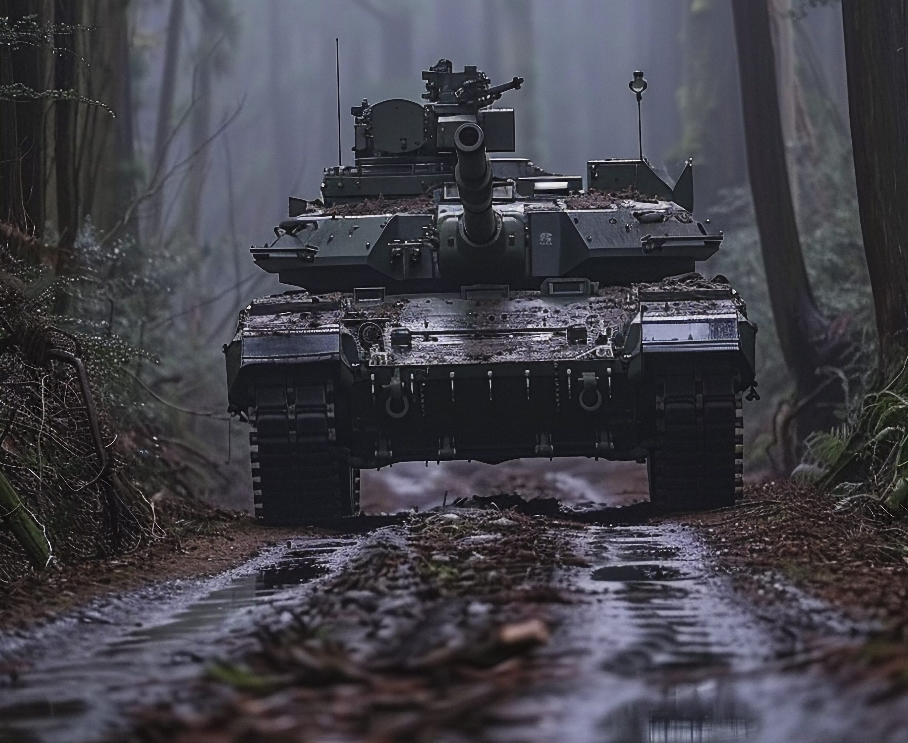
Military Applications
For military forces, mobility equals mission success. Soil moisture data support various activities such as route planning for armoured vehicles, off-road manoeuvrability assessments, engineering unit deployment, logistics convoy planning and airfield and temporary road construction. Heavy tracked vehicles (e.g., tanks) can become immobilised in saturated soils, delaying operations, increasing vulnerability, and potentially becoming easy targets.
Agriculture Applications
In agriculture, soil moisture determines when tractors can enter fields, risk of long-term soil compaction, timing of planting and harvesting, and equipment load limits. In addition, operating heavy machinery on wet soils can cause deep rutting, reduced infiltration, and lower crop yields. Precision agriculture increasingly uses soil moisture maps to schedule field operations and minimize structural damage.
Kappazeta’s Trafficability Solution
Whether for military operations or agricultural fieldwork, understanding soil moisture conditions can mean the difference between successful mobility and costly immobilization while accurate, timely trafficability information can reduce risk, improve efficiency, and protect land resources.
As mentioned in the previous blog post (See Part 1. Exploring the Significance of Open Landscape for Trafficability Mapping), the solution developed by Kappazeta has three parts. The parts constitute the open landscape, soil moisture, and trafficability models. Already covering most of Estonia, the trafficability models are built with scalability in mind, with international expansion planned in the next phase. Below, the flow chart offers a simple illustration of how the entire solution comes together from landscape dynamics to real-world mobility information.
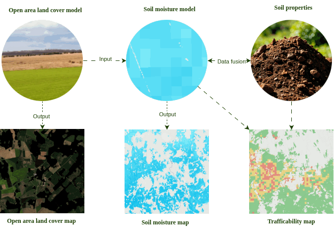
Our soil moisture model brings together various datasets. By combining derived soil moisture condition information with detailed terrain and soil properties, we create a dynamic map of how the ground behaves under different conditions.
But we do not stop there. The trafficability model takes this soil moisture information and integrates it with soil characteristics to determine whether a vehicle can pass and how easily. The output? A clear, intuitive trafficability map classified into three categories:
🟢 Go – conditions support safe movement
🟡 Slow-Go – proceed with caution
🔴 No-Go – high risk of immobilisation
What makes this approach especially potent is its adaptability. Trafficability is not a one-size-fits-all; it changes depending on a vehicle’s specific parameters, such as weight, tyre type, and ground pressure.
For example, a wheeled tractor with standard tyres and a military M1A1 vehicle will experience the same landscape very differently. Below, we display one-pass trafficability scenarios across three different dates in Estonia, highlighting how seasonal soil moisture variations significantly alter mobility outcomes.
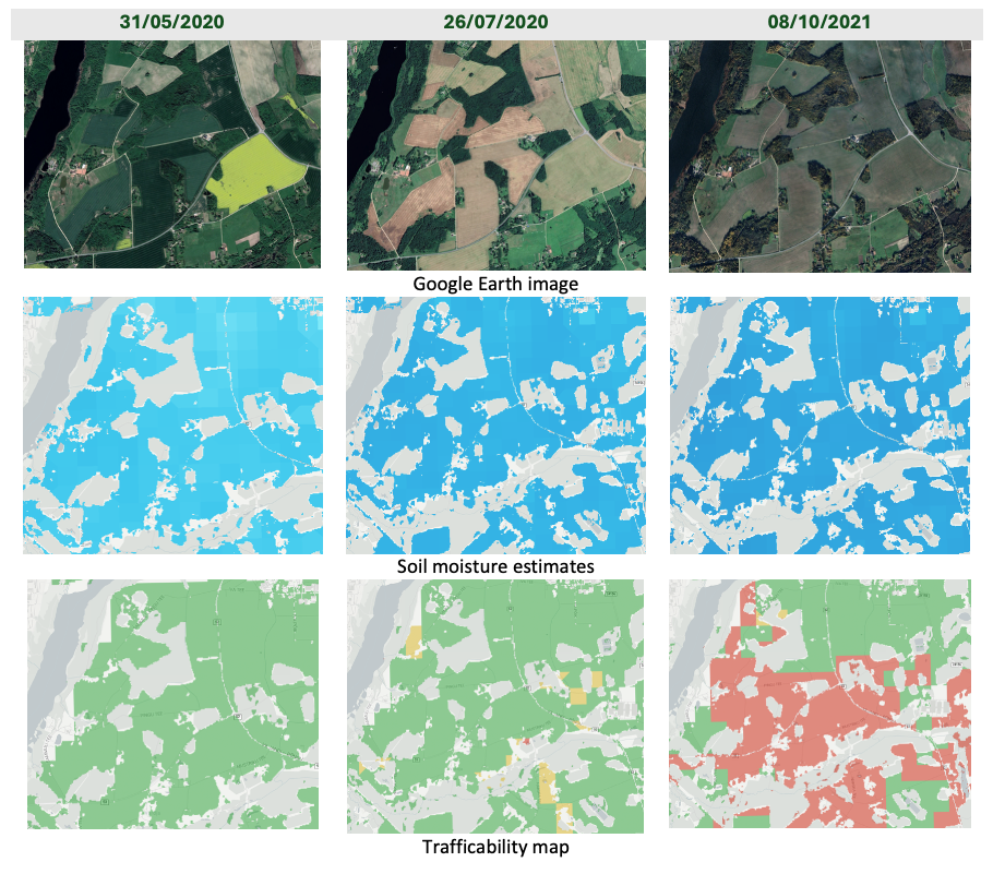
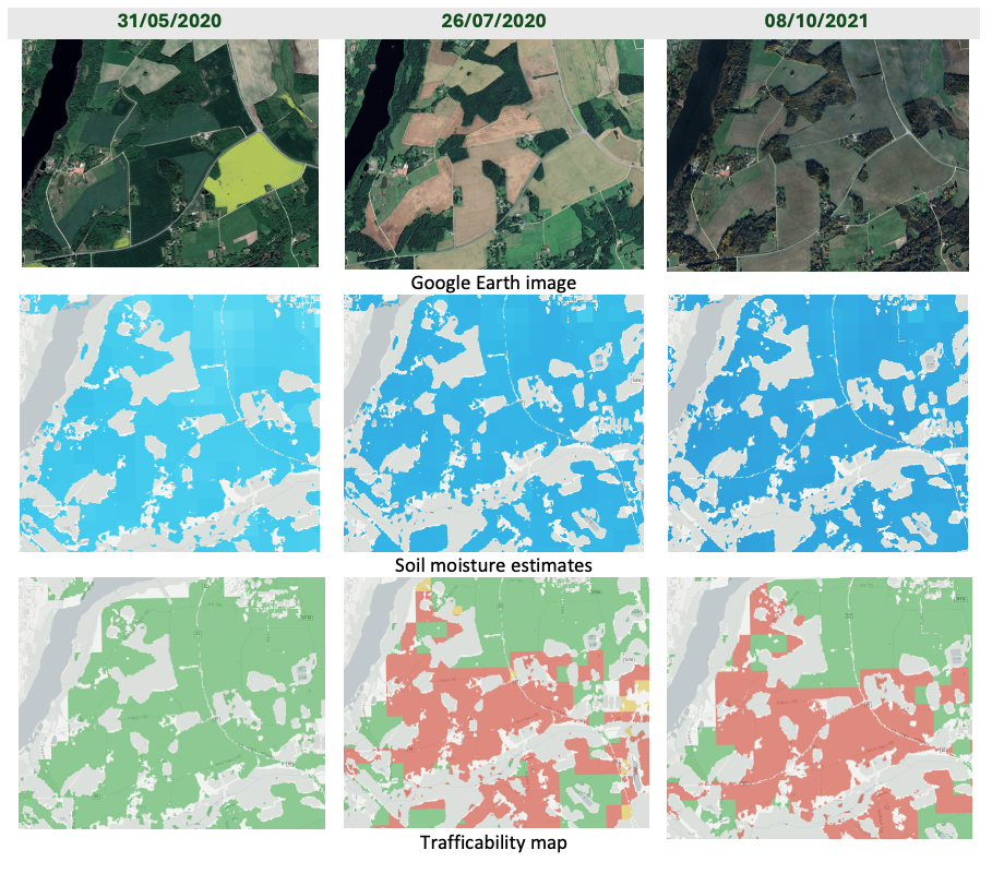
On the field, personalised timing and terrain trafficability intelligence make all the difference and getting it wrong might mean lost agricultural season for farmers or lost lives in the case of military operations.
Next Steps
We have now started testing the solution with different end users and use cases. If you find this relevant for your operations and would like to test our solution for your area of interest, then please contact us on kappazeta.ee
For more information on our trafficability map and other Defence solutions, see here or get in touch with us on kappazeta.ee